Fundy and St. John
Passamaquoddy Bay to Fredericton

Fundy and St. John
Passamaquoddy Bay to Fredericton
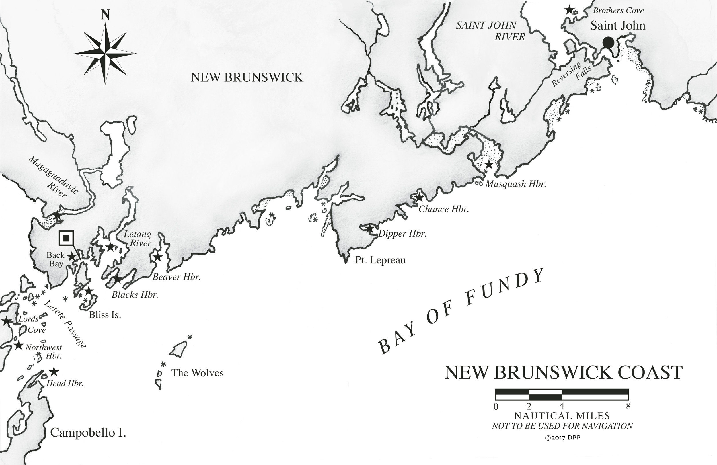
Once through the Grand Manan Channel, the wide-open and temperamental Bay of Fundy lies before you. Huge tides of icy water move in and out of the bay and turn warm, moist air into concrete-thick fog. When the wind blows against the strong currents, the bay is whipped into steep, unruly waves. At other times, Fundy lies under a glass surface, lulling, warm, and beguiling.
Fog is most prevalent in spring and early summer in light southerly winds of less than 10 knots. Ship reports indicate fog 30 percent of the time in July, the worst month, but this is an average. Between foggy days, other days can sparkle.
The shores of the Bay of Fundy are bold, with only a few harbors of refuge once past Grand Manan, Campobello, and the harbors of Passamaquoddy Bay. Even the shipping port of Saint John has exceptionally limited docking or anchoring options. This small metropolis lies at the mouth of the Saint John River, fortified along its waterfront by huge concrete container-ship terminals, oil tanks, a ferry terminal, cruise ship docks, and the Canadian Coast Guard. It is not an easy place for a yacht to lie.
Beyond the city, the dramatic Reversing Falls is the gatekeeper to the inland wonders of the Saint John River. Two irrefutable forces of nature meet at the falls—the enormous Fundy tides and the ceaseless seaward flow of the river. At low tides, the river cascades out to sea. At high tides, the sea surges upriver. And during the short slack periods, the falls are navigable by boat.
With surprising suddenness, you enter a different world, where the warm, fresh waters of the Saint John River stretch inland, tinged brown and smelling of rich earth. The fog is dissolved by the sun, the tides are measured in inches instead of meters, and salt is found only on your food. Languid arms and bays flood the valleys between the rolling hills, and wavelets lap at wooded shores and beaches of river sand.
Farther upriver, storybook cable ferries cross from one hamlet to another. Farms and pasture spill to the banks, and cows are barged to the low, grassy islands for grazing. The narrow tributary of the Jemseg River opens into wide Grand Lake, where the inland sailing is unobstructed and unsurpassed on the warm breezes. Fredericton, the capital of New Brunswick and the head of navigation, flanks the river just below the Mactaquac Dam.
It’s a 40-mile, day-long passage to Saint John from the area around the entrance to Passamaquoddy Bay. The passage is more complicated in timing than in navigation. The Bay of Fundy has very few harbors and Saint John has practically no overnight anchorage or dockage. Ideally, then, you time your arrival at the Reversing Falls near slack water, so you can proceed immediately up the Saint John River.
There are several good anchorages from which to depart: Head Harbour on Campobello; North Head on Grand Manan; Eastport, Lubec, and Saint Andrews in Passamaquoddy Bay; Back Bay, Letang River, or Blacks or Beaver Harbour near Letete Passage.
The Bay of Fundy is host to a large amount of shipping traffic, most of it converging on Saint John. Marine Communications and Traffic Services, based in Halifax, maintains a radar surveillance of the entire bay and helps direct the traffic, much like an air traffic controller. Also known as Fundy Traffic (506-426-4956), they should be monitored on channel 14 west of Point Lepreau or on channel 12 east of it. In limited visibility, you can identify yourself and your position, and they will monitor your progress in relation to other nearby ships. (If you choose to do this, be sure to maintain contact until you are secure, however, or they may initiate a search-and-rescue for you!) Be particularly alert for the ferry running between Grand Manan and Blacks Harbour and for shipping traffic in the lanes and anchorages outside Saint John.
At Saint John, the unique phenomenon of the Reversing Falls delays the upriver flow of current until slack water at the falls, about 3 hours and 50 minutes after low tide. During the delay, even while the tide is flooding, the current in the river and in the harbor is out-flowing. After slack water, the current flows upriver. It continues flowing upriver even during the first 2 hours and 25 minutes of the ebb, until the next slack water at the falls.
The delayed current, however, can work to your advantage. Plan to arrive in Saint John at least 4 hours after low when the current will be flowing upriver in your favor. You can start sailing on the last of the ebb in the Bay of Fundy, catch the beginning of the flood around Point Lepreau where the current is strong, and ride the flood to Saint John, arriving at the Reversing Falls just before slack water, when the current begins to flow upriver, and you can pass through the falls. If you have arrived in Saint John after slack at the Falls, Market Slip has very limited dockage in the heart of downtown, which allows you a brief exploration of this interesting city while waiting for the next slack water.
The following is placeholder text known as “lorem ipsum,” which is scrambled Latin used by designers to mimic real copy. Donec ac fringilla turpis. Aenean eu justo sed elit dignissim aliquam.
The following is placeholder text known as “lorem ipsum,” which is scrambled Latin used by designers to mimic real copy. Vestibulum ante ipsum primis in faucibus orci luctus et ultrices posuere cubilia Curae. Donec ac fringilla turpis.
The following is placeholder text known as “lorem ipsum,” which is scrambled Latin used by designers to mimic real copy. Vivamus sit amet semper lacus, in mollis libero. Donec eu est non lacus lacinia semper.